Airborne PM2.5 Measurements

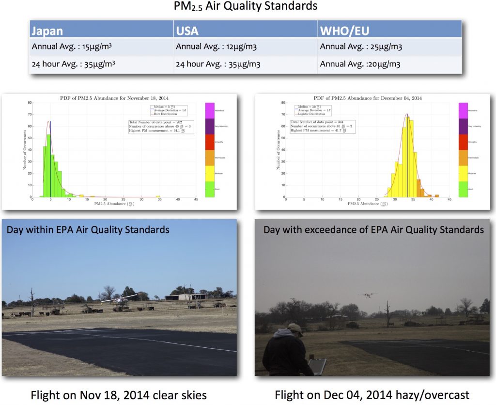
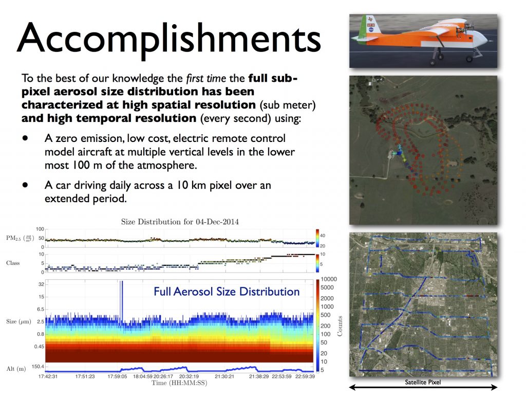
The atmospheric boundary layer is characterized by sharp vertical aerosol gradients. We have been making airborne measurements of PM2.5 in the boundary layer using a zero emission electric model aircraft. In addition to the vertical variability, large day to day variability can also be observed as shown below.

Contrast

Accomplishments

Airborne Networks

Unmanned airborne networks (ANs), as a representative but highly challenging mobile complex information system (CIS), have recently attracted significant interest across a multitude of agencies. This growing interest is stimulated by the advantages of unmanned aerial vehicles (UAVs), such as transportability, wide coverage and unmanned maneuvering, and also by direct flight-to-flight communication schemes such as small delay, high throughput and flexibility. These advantages give rise to broad novel applications including next-generation air traffic control, search and rescue, surveillance, cargo transportation, and on-demand creation of communication network infrastructure after disasters, among others.

Despite these advantages and broad applications of unmanned ANs, the research is still at its very early stage, due to the highly complex, mobile, and varying AN structure, heterogeneous communication environment, and very limited power and computation resources. In order to overcome these difficulties, it is crucial for academia, industry, and international researchers to cohesively collaborate and share multi-source information and test-beds.

This international seminar will serve as a starting point to propel research progress in this emerging field. We expect that a series of such events will lead to strong international collaboration, funding opportunities, and fruitful research outputs.

Talk on Applications of Aerial Networks

Workshop Agenda

SHARP 2014

Invited to speak at Symposium on Healthcare and Analytics in Research and Practice (SHARP 2014) as part of a panel on Analytics Powering Smart Cities and a session on Smart and Connected Cities. The use of big data and analytics approaches in the fields of science, technology and business is promising and set to grow over the next several years. The adoption of such approaches should lead toward the development of next-generation innovation that is widely adopted in organizations and localized communities but are also sharable over high-speed, gigabit cyber-networks such as the government’s Geni initiative. Analytics-driven developments in various spheres such as healthcare, smart grid, public health, consumer, etc. can strongly influence the technological evolution, guide policy making, while reshaping the future and catalyze the innovation culture at the global, regional and metropolitan levels. Various private and public open-data initiatives will be key drivers for this change. Such an approach requires a new thinking blended with state-of-art new business, technology and analytics skills and strong scientific research.


US Ignite Award for THRIVE

THRIVE-Award-Small

THRIVE: Timely Health Indicators using Remote Sensing & Innovation for the Vitality of the Environment

Blog post in the Modern Network

Earth observations have been used for decades to benefit society. The Veterans Administration (VA) is the country’s largest health care provider, caring for seven million veterans. The project is aimed at enhancing the VA decision support tools in the area of public health and air quality utilizing multiple NASA Satellite and Earth Science Model Products. This environmental information will be integrated with the VA’s Decision Support Systems.

The project is based on a close collaboration with the VA to provide a three-fold enhancement of the existing VA decision support, namely:

  1. Personalized Health Alerts for Patients in the existing MyHealtheVet tool.
  2. New Tool for Logistical Planning for Emergency Rooms and Clinics.
  3. Improved Diagnosis Tools for Physicians.

We learn from the past to inform the future by using machine learning to determine the mapping from historical VA hospital admissions (all ICD codes) and prescriptions over the last decade to the environmental data provided by a suite of NASA products. The key goal is the sustained routine use of the NASA products beyond the end of this project.

The proposition being developed and tested is that global daily high resolution air quality data delivered as a web service is of tremendous measurable value for multiple application verticals in a suite of decision support tools. The daily data products derived from a suite of NASA datasets using machine learning will allow provision of proactive health care by the country’s largest health care provider, the VA, and proactive policy making and environmental reporting for the municipality of San Leandro, CA.

We will utilize the UTD Innovative Virtual Platform for Research Collaboration and Application (a state of the art telepresence facility) to have regular videoconferences with our partners across the country.

See other US-Ignite apps. US-Ignite is fostering the development of next- generation applications. They help developers, communities, individuals, and partners bring gigabit applications to life.

NTx Apps Kickoff

The NTx Apps Challenge launches with a bang at our Challenge Kickoff on July 24th at The DEC. Join us for an evening of great ideas and dynamic speakers, including Calvin Carter, CEO of Bottle Rocket, Dr. David Lary, Professor at University of Texas at Dallas, and Scott Harper, Co-CEO and Co-Founder of Dialexa.

Come learn about this year’s Challenge Verticals, check out some cutting-edge product demos, network with our amazing Challenge Mentors, and start building your dream dev team for your shot at $80k in prizes.

Whether you are a hacker, a designer, an entrepreneuer, or just someone with a good idea, you will not want to miss this spectacular night!

US Ignite Application Summit 2014

US Ignite fosters the creation of next-generation Internet applications that provide transformative public benefit. By engaging diverse public and private leaders we “ignite” the development and deployment of new applications with profound impact on how Americans work, live, learn and play. To learn more visit www.us-ignite.org.

Making CH4 Measurements

We have made measurements using an electric, zero emissions, remote control model aircraft equipped with a compact methane sensor to quantify CH4 emissions around near-field gas and oil facilities. The remote control aircraft can sample much closer to local sources than conventional manned craft and higher maneuverability.

The scientific objectives are to address the following questions:
What are CH4 plume sizes and magnitudes from gas/oil facilities?
What are the spatial and temporal characteristics of the CH4 plumes?
What are the emissions of methane from these sources?